Hiking Gothic Basin to Foggy Lake
It's been some time since I blogged about a hike. As many places as I've hiked since moving to Seattle, I could probably bore you to death with stories of them all.
Today, though, I headed out to Gothic Basin. Aside from the cool name (apparently named for a guy named Gothic, but whatever), things I've read about the hike were enticing. We don't want for beautiful scenery here in Washington, but some spots stand out.
To get to this particular spot, though, you must work. A rule of hiking in the Cascades seems to be that the more you have to exert yourself, the more you get back in terms of views, solitude and more.
As I sit here tonight, I'm not in nearly as bad shape as I was when I finished the Harper Creek hike I blogged back in 2009. But I'm still bruised, blistered and tired from a hike that easily ranks as one of the toughest I've completed.
The Washington Trails Association has a fairly good writeup on the hike. However, I've learned that trail guides for these things aren't ever as detailed as I'd prefer and, fact of the matter is that when you're going to give up a whole day to do a hike that has a high payoff but also a fair degree of danger, you want as much information as possible.
To get to Gothic Basin, you start by driving the Mountain Loop Highway from the hamlet of Granite Falls, WA. The drive is honestly a pleasure. With so many hikes in WA accessible only from potholed Forest Service roads, the Mountain Loop Highway is a joy. Parking at Barlow Pass, you start down the closed-to-traffic Monte Cristo Road, which once served the mining town of Monte Cristo (still there as a ghost town, I hear).
The Monte Cristo Road is also a pleasure. A wide, graded path... you can tell it was once a road. After a mile you get to a spot where the South Fork Sauk River had other ideas of what to do with the land than having a road there. At this point, you start on the Weden Creek Trail (my NatGeo Trails Illustrated map has it as Weeden Creek, the Forest Service has it as Weden. Whatever.)
This first part of the trail through forest is fine for about half a mile. I was trying to go as fast as I could on the section to this point (made it to a major creek crossing in 30 mins) as I knew what was ahead.
So it begins... over the next three miles, hikers must climb about 3,000'. To put this in perspective, San Francisco's Filbert Street has a section that is one of the steepest drivable pitches in the world. On Filbert Street, just about every three feet you drive, you've dropped a foot in elevation. To do 3,000' feet in three miles, you need to gain a foot every time you walk a bit less than 5.5 feet. So, this isn't Filbert Street, but it's probably steeper than anything you regularly encounter.
Of course that climb isn't uniform. The first mile of climbing is stupid steep in spots. And save for a few spots, it is entirely wooded. You're slogging up a mountainside, realizing (if you're me) that you're not as young as you used to be. I had to stop every switchback to catch my breath and hydrate. It's trails like this where you have to remember that this isn't a race.
After a mile you come to a spectacular rocky clearing where there is a creek crossing. Really, a waterfall crossing. In the August weather, with no snow, it is a spot that requires some care. In spring, if this is snowy, this spot could honestly be fatal. A slip here could have you landing on something not nearly as cushion-y as you might prefer and, potentially, well down a ravine.
You could be forgiven for stopping here. The view across the valley is spectacular. You've done a huge climb. Some hikes, this is all you can expect to get. Not on the Weden Creek Trail...
What the next two miles of trail lack in terms of sadistically steep trail, it makes up for in sheer challenge. At first, things seem lovely. You even get to go DOWN slightly, though, if you're smart, you realize you're going to have to climb those feet back up. The mountain top isn't down, after all.
Then it happens. Rocks. The trail is decidedly rocky here and there are several sections where you have to go hand-over-hand to pull yourself over some rocks. Many people like to hike with their dogs. I saw a handful on this section. I feel like calling the ASPCA on these people. I was hiking and sweating voluntarily, at least.
The trail is also, generally, fully exposed at this point. The good side to that is every slogging step, every rock you hop, the view gets better and better. If the view was amazing before, it's full-on gorgeous and about to get obscene at the top.
But you're not there yet. At all. And, hey... how much water did you bring? I went through about 3.5 liters on this hike. I saw people hiking with a bottle of Dasani. That is not going to work. Plan ahead. There is no cell phone service anywhere on this hike, nor will you get any until you are basically back to Granite Falls. You get in trouble here... you are in trouble. Real trouble. The sad part is not only water fairly easy to carry, but there are tons of places to fill up a filter bottle on the hike. You need not run out of water.
Oh hey, we're still climbing. Good lord, we're still climbing. If you do this hike, get used to looking up and seeing the trail continue upwards in front of you.
Finally, you reach Gothic Basin. It is... an alpine wonderland. Meadows. Tarns. High peaks with lingering snow. I cannot possibly describe this properly, so I won't try. I will say the prettiest alpine meadows I've ever seen are in Mt. Rainier National Park. The meadows in Gothic Basin are in the same league.
Exhausted, I found a rock overlooking a pretty tarn and, honestly, thought I was done. And, really, you could be forgiven for stopping here. It's a great spot. You've just climbed the height of Burj Khalifa. So I was done. I grabbed my food and water and took in the scene.
Except Foggy Lake is up there. That's the real end of the trail. It's the "destination" for everyone who starts this hike. What's another 300 feet of climbing? I may not do this trail again. If I do, it will again be in August as this is an area you can really only hike to in August if you 1) want to be safe and 2) don't want to encounter a snow-filled basin (sometimes, Gothic is snowy into September).
So off I went... if this was going to be my only trip up this trail, let's do it all.
Except where the hell is the trail? My map says it's on the south side of the tarn. It's so not. I'm making my own way up to a high ridge line and hating myself like crazy for doing a moment more of climbing. I can see Gothic and Del Campo Peaks, which flank Foggy Lake, but when the hell do I get there. Finally, a cairn! And then another. Could someone PLEASE put more cairns up here? This is promising. And then...
 You could spend all day here.
But... you don't live at Foggy Lake. You live in Seattle. And every step you took up this mountain must be taken down.
It is a rare thing for a descent to take as long as a climb. But all those rocks that where a blast to scramble over going up? You have to figure out how to go down them without helping gravity help you on your way to a grave injury.
I have no idea how anyone does this descent without trekking poles. I'd still be there if I didn't have them. As it stands, even with my magic trekking poles, I have managed to bruise up my toes from rocks, roots and other delights. I have never had to climb down something like this and, honestly, if you're not thinking through some steps, you could get yourself in a lot of trouble.
Of course, those downhill sections of respite you had on the climb up? Yeah, you go up those now and you want to shoot someone.
This is a trail that deserves respect from hikers. This is not one for the family. This is not one for dogs. This is trail that can push even an experienced hiker and should be treated as such. There are very real hazards, it is a climb that I would wager many people shouldn't even attempt.
But those who do plan. Those who train for these late summer Cascades hikes by hiking most of the year on smaller trails... this trail is why you do that. On the Horizon are mountains higher than any point in 36 states! You can look into the clearest water lake you could conceive of. You can stand in snow on August 18.
As I type this, the thought of scaling the Weden Creek Trail again is, at best, daunting. But, already, I can feel the pull on the back of my mind. There were sights I saw today that surpass many I've seen hiking anywhere. There was more ground to explore. And as I rest my sore legs and feet, my biggest regret is I didn't leave for the trail a bit earlier.
Today, though, I headed out to Gothic Basin. Aside from the cool name (apparently named for a guy named Gothic, but whatever), things I've read about the hike were enticing. We don't want for beautiful scenery here in Washington, but some spots stand out.
To get to this particular spot, though, you must work. A rule of hiking in the Cascades seems to be that the more you have to exert yourself, the more you get back in terms of views, solitude and more.
As I sit here tonight, I'm not in nearly as bad shape as I was when I finished the Harper Creek hike I blogged back in 2009. But I'm still bruised, blistered and tired from a hike that easily ranks as one of the toughest I've completed.
The Washington Trails Association has a fairly good writeup on the hike. However, I've learned that trail guides for these things aren't ever as detailed as I'd prefer and, fact of the matter is that when you're going to give up a whole day to do a hike that has a high payoff but also a fair degree of danger, you want as much information as possible.
To get to Gothic Basin, you start by driving the Mountain Loop Highway from the hamlet of Granite Falls, WA. The drive is honestly a pleasure. With so many hikes in WA accessible only from potholed Forest Service roads, the Mountain Loop Highway is a joy. Parking at Barlow Pass, you start down the closed-to-traffic Monte Cristo Road, which once served the mining town of Monte Cristo (still there as a ghost town, I hear).
The Monte Cristo Road is also a pleasure. A wide, graded path... you can tell it was once a road. After a mile you get to a spot where the South Fork Sauk River had other ideas of what to do with the land than having a road there. At this point, you start on the Weden Creek Trail (my NatGeo Trails Illustrated map has it as Weeden Creek, the Forest Service has it as Weden. Whatever.)
This first part of the trail through forest is fine for about half a mile. I was trying to go as fast as I could on the section to this point (made it to a major creek crossing in 30 mins) as I knew what was ahead.
So it begins... over the next three miles, hikers must climb about 3,000'. To put this in perspective, San Francisco's Filbert Street has a section that is one of the steepest drivable pitches in the world. On Filbert Street, just about every three feet you drive, you've dropped a foot in elevation. To do 3,000' feet in three miles, you need to gain a foot every time you walk a bit less than 5.5 feet. So, this isn't Filbert Street, but it's probably steeper than anything you regularly encounter.
Of course that climb isn't uniform. The first mile of climbing is stupid steep in spots. And save for a few spots, it is entirely wooded. You're slogging up a mountainside, realizing (if you're me) that you're not as young as you used to be. I had to stop every switchback to catch my breath and hydrate. It's trails like this where you have to remember that this isn't a race.
After a mile you come to a spectacular rocky clearing where there is a creek crossing. Really, a waterfall crossing. In the August weather, with no snow, it is a spot that requires some care. In spring, if this is snowy, this spot could honestly be fatal. A slip here could have you landing on something not nearly as cushion-y as you might prefer and, potentially, well down a ravine.
You could be forgiven for stopping here. The view across the valley is spectacular. You've done a huge climb. Some hikes, this is all you can expect to get. Not on the Weden Creek Trail...
What the next two miles of trail lack in terms of sadistically steep trail, it makes up for in sheer challenge. At first, things seem lovely. You even get to go DOWN slightly, though, if you're smart, you realize you're going to have to climb those feet back up. The mountain top isn't down, after all.
Then it happens. Rocks. The trail is decidedly rocky here and there are several sections where you have to go hand-over-hand to pull yourself over some rocks. Many people like to hike with their dogs. I saw a handful on this section. I feel like calling the ASPCA on these people. I was hiking and sweating voluntarily, at least.
The trail is also, generally, fully exposed at this point. The good side to that is every slogging step, every rock you hop, the view gets better and better. If the view was amazing before, it's full-on gorgeous and about to get obscene at the top.
But you're not there yet. At all. And, hey... how much water did you bring? I went through about 3.5 liters on this hike. I saw people hiking with a bottle of Dasani. That is not going to work. Plan ahead. There is no cell phone service anywhere on this hike, nor will you get any until you are basically back to Granite Falls. You get in trouble here... you are in trouble. Real trouble. The sad part is not only water fairly easy to carry, but there are tons of places to fill up a filter bottle on the hike. You need not run out of water.
Oh hey, we're still climbing. Good lord, we're still climbing. If you do this hike, get used to looking up and seeing the trail continue upwards in front of you.
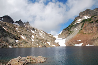
Finally, you reach Gothic Basin. It is... an alpine wonderland. Meadows. Tarns. High peaks with lingering snow. I cannot possibly describe this properly, so I won't try. I will say the prettiest alpine meadows I've ever seen are in Mt. Rainier National Park. The meadows in Gothic Basin are in the same league.
Exhausted, I found a rock overlooking a pretty tarn and, honestly, thought I was done. And, really, you could be forgiven for stopping here. It's a great spot. You've just climbed the height of Burj Khalifa. So I was done. I grabbed my food and water and took in the scene.
Except Foggy Lake is up there. That's the real end of the trail. It's the "destination" for everyone who starts this hike. What's another 300 feet of climbing? I may not do this trail again. If I do, it will again be in August as this is an area you can really only hike to in August if you 1) want to be safe and 2) don't want to encounter a snow-filled basin (sometimes, Gothic is snowy into September).
So off I went... if this was going to be my only trip up this trail, let's do it all.
Except where the hell is the trail? My map says it's on the south side of the tarn. It's so not. I'm making my own way up to a high ridge line and hating myself like crazy for doing a moment more of climbing. I can see Gothic and Del Campo Peaks, which flank Foggy Lake, but when the hell do I get there. Finally, a cairn! And then another. Could someone PLEASE put more cairns up here? This is promising. And then...

But... you don't live at Foggy Lake. You live in Seattle. And every step you took up this mountain must be taken down.
It is a rare thing for a descent to take as long as a climb. But all those rocks that where a blast to scramble over going up? You have to figure out how to go down them without helping gravity help you on your way to a grave injury.
I have no idea how anyone does this descent without trekking poles. I'd still be there if I didn't have them. As it stands, even with my magic trekking poles, I have managed to bruise up my toes from rocks, roots and other delights. I have never had to climb down something like this and, honestly, if you're not thinking through some steps, you could get yourself in a lot of trouble.
Of course, those downhill sections of respite you had on the climb up? Yeah, you go up those now and you want to shoot someone.
This is a trail that deserves respect from hikers. This is not one for the family. This is not one for dogs. This is trail that can push even an experienced hiker and should be treated as such. There are very real hazards, it is a climb that I would wager many people shouldn't even attempt.
But those who do plan. Those who train for these late summer Cascades hikes by hiking most of the year on smaller trails... this trail is why you do that. On the Horizon are mountains higher than any point in 36 states! You can look into the clearest water lake you could conceive of. You can stand in snow on August 18.
As I type this, the thought of scaling the Weden Creek Trail again is, at best, daunting. But, already, I can feel the pull on the back of my mind. There were sights I saw today that surpass many I've seen hiking anywhere. There was more ground to explore. And as I rest my sore legs and feet, my biggest regret is I didn't leave for the trail a bit earlier.

Comments